—Eyelash viper, Bushmaster, Coral, and other venomous snakes are mostly peaceful creatures. However, the Fer-de-lance (French for spearhead) is camouflaged and will strike unprovoked. It’s a nasty little bugger that needs to be watched out for. Never step over a log without knowing what’s on the other side and remember, they can be hiding in the trees as well. I looked into buying antivenins but they are extremely costly and you need specific concoctions for specific snakes.
—Sharp tingling sensation on the body that flares when hot or sweating is likely a byproduct of fungus growing on clothes. Washing clothes with soap and water seemed to resolve the issue. Antifungal cream (Tinactin) was applied to affected skin as well. Tinactin saved my feet in Guyana from a debilitating case of Jungle Rot. (See pic below)
Trench Foot and Jungle Rot are terms often used interchangeably but are different maladies. Trench Foot is a term coined by the men who fought in the trenches of WWI. This is an immersion issue. Wet feet kept in damp, cold environments (like combat boots) for long periods of time can cause the flesh to die and sluff off. Simply drying your feet at the end of the day will prevent this. Jungle Rot, however, is a debilitating fungal infection which drying alone won’t cure. At first it feels like a severe case of Athlete’s Foot: tingling and cracking between the toes. The issue progresses rapidly until it feels like you are walking on broken glass. Look HERE for good advice on preventing Jungle Rot.
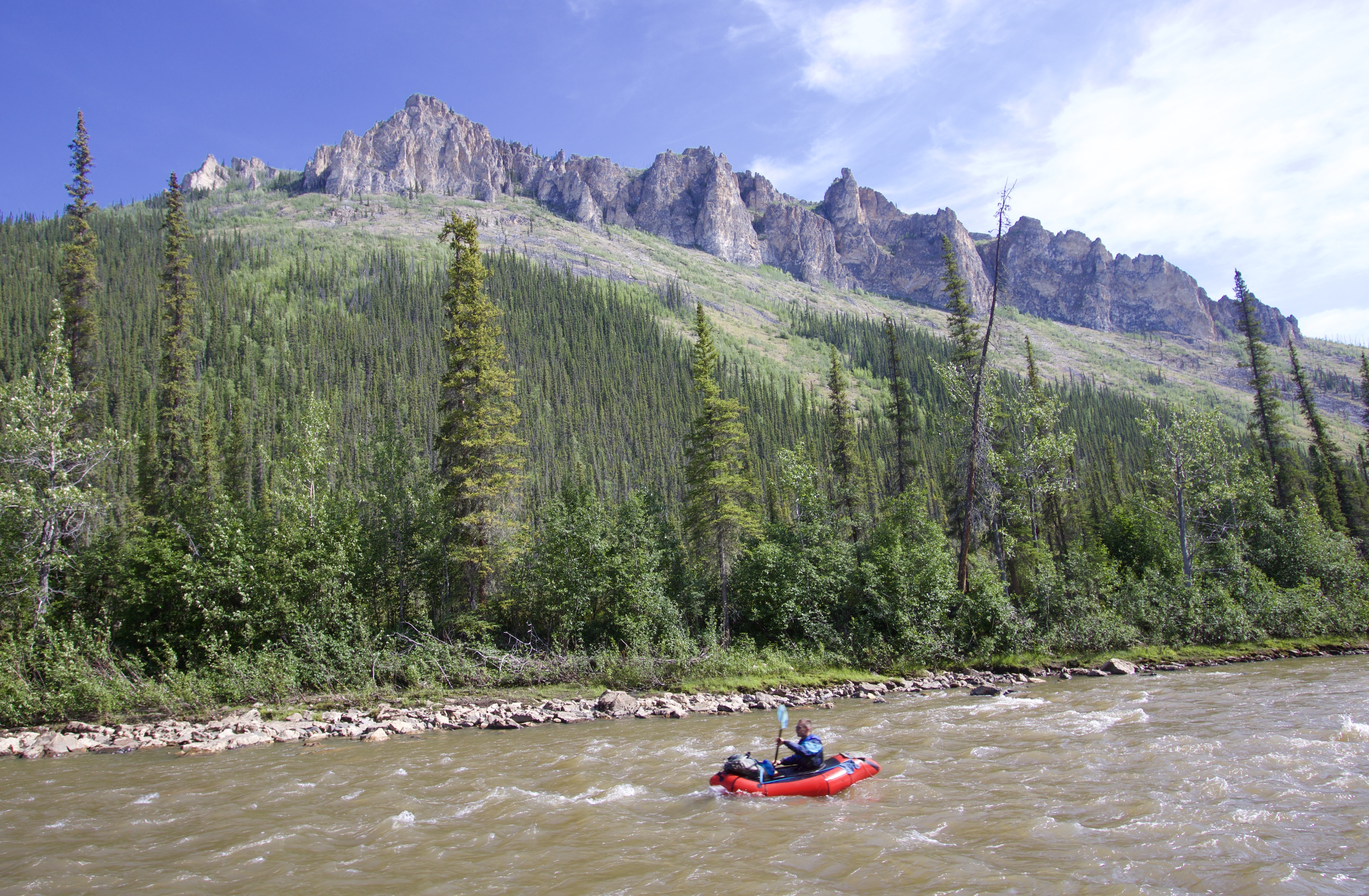
—Rocks are a good deterrent against overly curious caiman (alligators). Carry them in your packraft while floating. Flare gun might have been useful to scare off the jaguar we encountered. Maybe. Whistles on the other hand seemed to excite him. The shrill noise may have resembled the screams of an injured animal.
—Once away from the riverbanks where foliage can grow thick, primary rainforest is fairly easy to walk through. It’s not like bushwhacking, as the shade from the canopy prevents thick undergrowth. Mostly. But it’s very easy to get turned around. On the Rewa River, Paul Smotherman and I went in circles and didn’t believe our compass. GPS doesn’t work under thick canopy so be careful. If venturing into the jungle, don’t lose sight of the river.
—Machetes are required and so is the skill to use them. A file to sharpen the blade is also a must. I’ve bought cheap machetes and the metal is worthless. Might as well bring a good one from the states. Be aware that a self-inflicted machete wound could lead to a disastrous situation in a remote environment.
—Always find camp well before dusk and the nightly feeding frenzy. Caiman are nocturnal, not a good idea to be paddling at night. Camp well away from the water’s edge. Start looking for your campsite around 4pm.
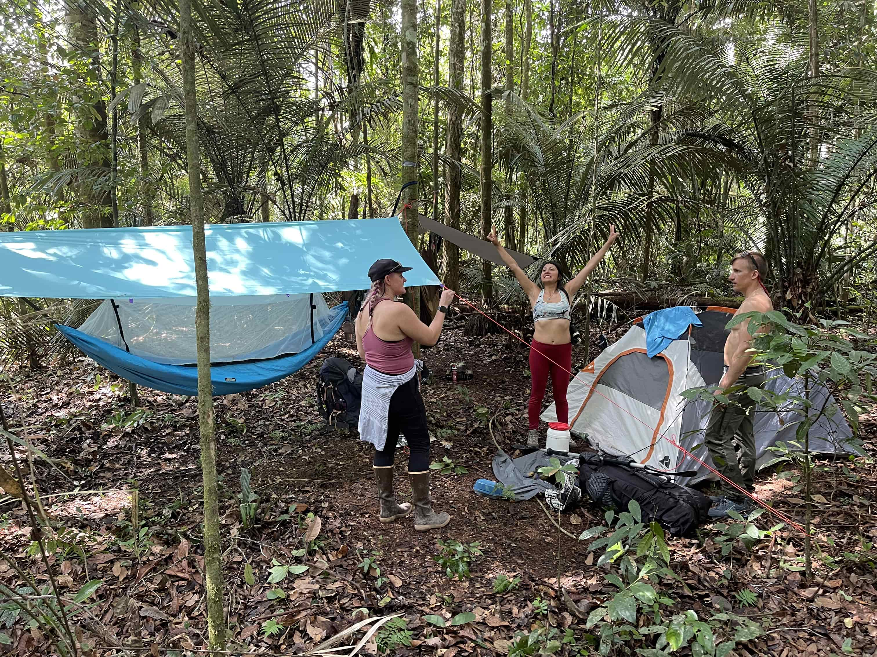
—Campsites are best found in the jungle, not on the beaches. This is opposite from what most river runners are used to. Ashlee and I used hammocks and the Eddy’s used a tent. Both options have their advantages and disadvantages. It takes much longer to set up a hammock and you need to find two sturdy trees. But if the ground is sufficiently wet or it rains hard, the tent will form pools of water inside that make for an uncomfortable night. Because I am tall, I prefer a double hammock which allows me to sleep in a more horizontal position. I prefer the mosquito netting attached instead of the ‘wizard sleeve’ set up. We sprayed the bottom of our hammocks and hammock straps with permethrin to keep the mosquitos, ants, and ticks off. We found permethrin at Tomahawk (the REI of Suriname).
At first, the jungle at night is unbearably hot. The hammock campers will be glad to have air circulating around them. At about 1am, however, the temperature drops and due to the high humidity, it becomes surprisingly cold. Then the tent campers will be glad they chose their particular shelter. Either way, everyone needs a lightweight sleeping bag. Pro Tip: Clear the leaves and foliage away from your hammock and tent. It will be easier to see creepy crawlies and ants won’t like it. Also, ants are attracted to the salt in urine, so pee well away from your camping area.
—Campfires are wonderful. But the rain and humidity can make them difficult to start. I found bringing cotton balls dipped in vaseline is a great firestarter. Don’t build your campfire directly on the ground as it will absorb the water and extinguish the flame. Instead, split a piece of dead wood and light atop the two dry halves. You will need about an hour of daylight to collect enough firewood for the night. Even with a good headlamp I found it difficult to find usable firewood at night.
—They sell a few different stoves and fuel types at Tomahawk but we found their isobutane/propane canisters were unthreaded and weren’t compatible with our Jetboil-type screw-on stoves. At the last minute we bought a large Coleman style stove, which was heavy and not fun to portage with.
—Bathing: By all means, swim in the river. But not at night! And if I were you I’d keep my trousers on. The red-bellied piranha are small and it takes a lot of them to do much damage. The black piranha, however, are conniving (and cannibalistic) and large enough to bite your dick off. I met a villager in Guyana with a baseball-sized chunk missing from his leg. He said a piranha did it. Also, women should not bathe while menstruating for obvious reasons. Also the candiru, a toothpick-sized parasitic catfish, has a fondness for swimming up an unsuspecting person’s anus, vagina, and surprisingly—even a man’s urethra. Once inside, it flares its spines and feeds on the resulting blood. The fish must be surgically removed.
—Sunblock is a must. Large brimmed hat helps to prevent sun burns.
—The airstrip at Raleighvallen (Foengoe/Fungu Island) is overgrown and not currently safe for landing fixed-wing aircraft. There is apparently no way to contact anyone at Raleighvallen as they do not have a satellite phone or InReach. There is no food to buy in Raleighvallen (or much of anything else) but the few locals there will sell you warm beer.
—To treat river-water, our group used a combination of SteriPEN and Aquamira. Silty water can make the ultraviolet light of the SteriPEN less effective. I’ve tried various filters (pump, gravity) to remove the silt but they clog easily. Another way to remove silt is to boil the water hard for a few minutes, then let the water cool. The silt will separate from the water as it cools. Afterwards, pour the clear water off the top into your bottle. The boiling also purifies the water. An MSR Dromedary is nice if you find a clear water stream. Fill it up and carry the silt-free water with you.
—Statistically, you are most likely to die in the jungle by being struck by a falling tree. Massive, healthy-looking hardwoods rot from the inside and can fall unexpectedly, especially after a hard rain. Choose your campsites well. Cody Dial, from Alaska, ventured into the jungle of Costa Rica and disappeared. Most suspected foul play. Two years later his skeleton was found; he’d been crushed by a falling tree.
In summation: Careful of snakes, falling trees, and dick-eating fish.
GEAR LIST:
Paddle Gear
Packraft
Paddle (four piece)
Bow bag
Twinky Tubes X2
Inflation bag
PFD
Large Backpack
Duffel
Drybags
Repair kit
Duct tape
Tyvek Tape
Tooth floss + needles
Packraft repair patches, etc.
Camping
Hammock w/mosquito screen attached
Hennessy Hex Fly
Hammock straps 2X10ft
Carabiners X4
MSR Ground Hog stakes X10
Extra parachute cord (clothes line)
Lightweight sleeping bag
Small 2ft X 4ft ground tarp (for getting in and out of hammock)
Inflatable pillow (luxury)
Stove (could not find jetboil screw-on canisters at Tomahawk)
Fuel
Aluminum Pot
Pot grabber
Mug X2 (used as bowl as well)
Spoon X2
Knife
Headlamp + Batteries (+ spare headlamp)
Clothes
Rain jacket
Long sleeve synthetic button down (primary)
Underware X2
Quick dry pants
Fleece Pants
Dry camp shirt
Crocs
Socks for river
Waterproof dry bagX 2
Buff
Wristwatch
Belt (not leather)
Tennis shoes for river
Navigation
Waterproof Maps
Compass
iPhone, Gaia/Earthmate/CalTopo (CalTopo seemed to be the best)
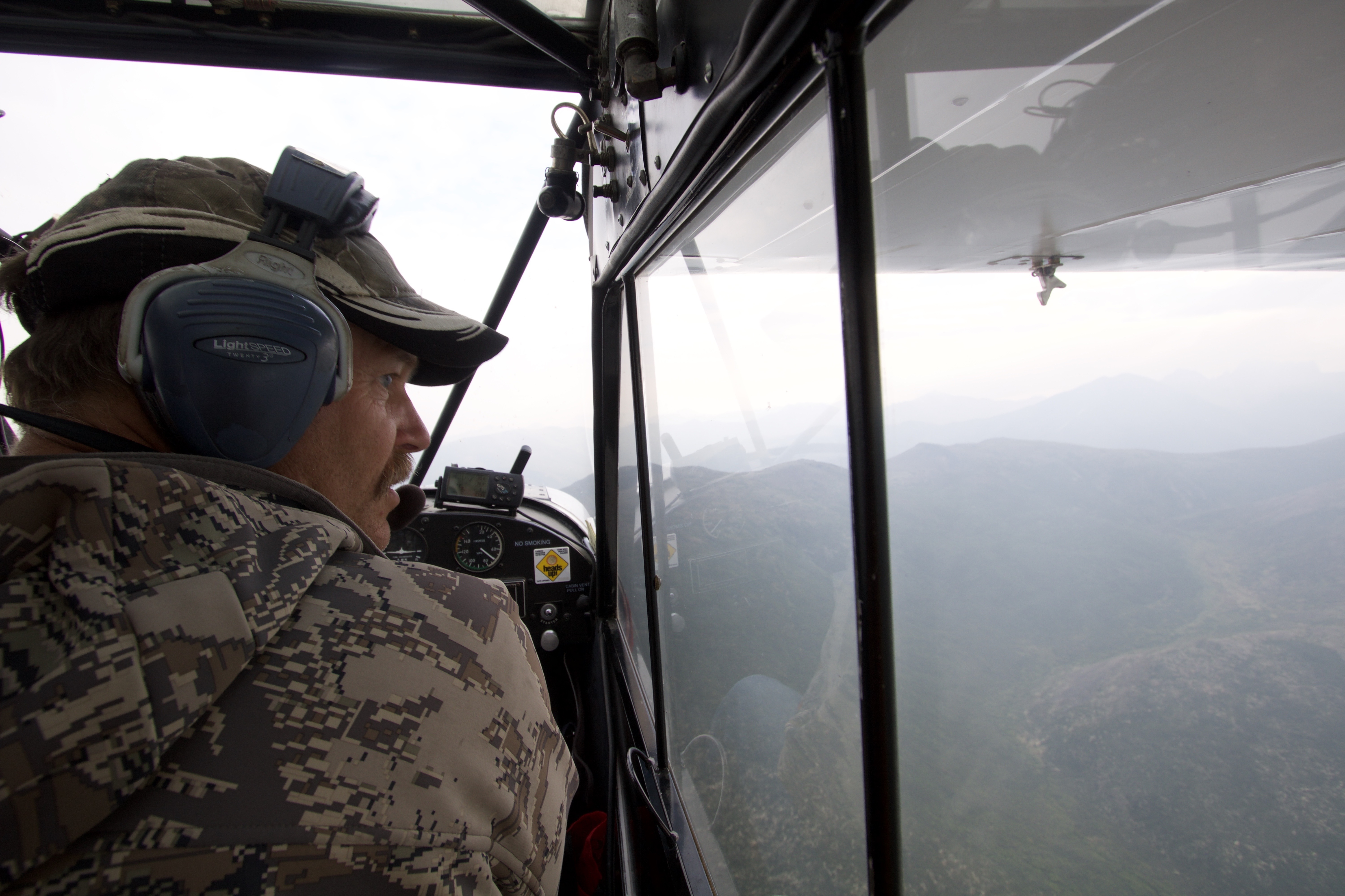
“I don’t even like to fly over that canyon,” said Dan Reynolds, the bush pilot and hunting guide who was flying me to the headwaters of the Tatonduk River––an obscure ribbon of whitewater I had obsessed over for the better part of two years. The canyon in question was the crux along our paddling objective. It was the reason why people didn’t go there.
Dan owns a massive hunting concession which extends from his cabin near Dawson City, Yukon Territory, all the way to the Alaska border––6000-square miles of some of the most remote, pristine areas of North America. Our goal, the Tatonduk River, flows directly through it.
Ueli and Oli loading the Super Cub
“I take 12 hunters out a year,” Dan said. “That’s what the land can support.” As we flew over the area in his Super Cub––a one passenger, supercharged monoplane, with cartoonish oversized tundra tires––I realized that everything below us, the forests, rivers, mountains, all of it, stretching into the horizon––is all Dan’s. And I was a little curious why he had limited his clients to so few. Wealthy, big-game hunters from all over the world want to hunt moose, caribou, Dall sheep, wolves, and even grizzly bear on his concession. A guided moose hunt, for instance, averages $23,000 US dollars per client. With prices like these, Dan’s backyard is a veritable goldmine. However, he didn’t seem to care about this. His interest lies in game management. “It was a hard winter for the Dall sheep,” he mused. “There are half as many as there were last summer.”
Dan Reynolds flying his Super Cub. Smokey haze from forest fire (not nearby).
Dan has a small cabin with a primitive airstrip on the bank of the Tatonduk. His father owned it before him, along with the hunting concession, and he’s been coming since he was a child. As we neared, I saw a huge trail leading down to a grassy meadow beside the river. It was a game trail, or perhaps a game highway, the Dall sheep had rutted-out over the centuries. This was where the ewes came to give birth. Dan banked the plane hard to avoid the area and startle the animals. The river had recently flooded and took out half the airstrip but Reynolds maneuvered the Super Cub expertly and lands in an area small enough for a helicopter pilot to be proud of. He dropped me off, then flew back to retrieve my two friends, Oliver Amann and Ueli Staub. The plane, as well as the airstrip, is only big enough to fly us in one at a time.
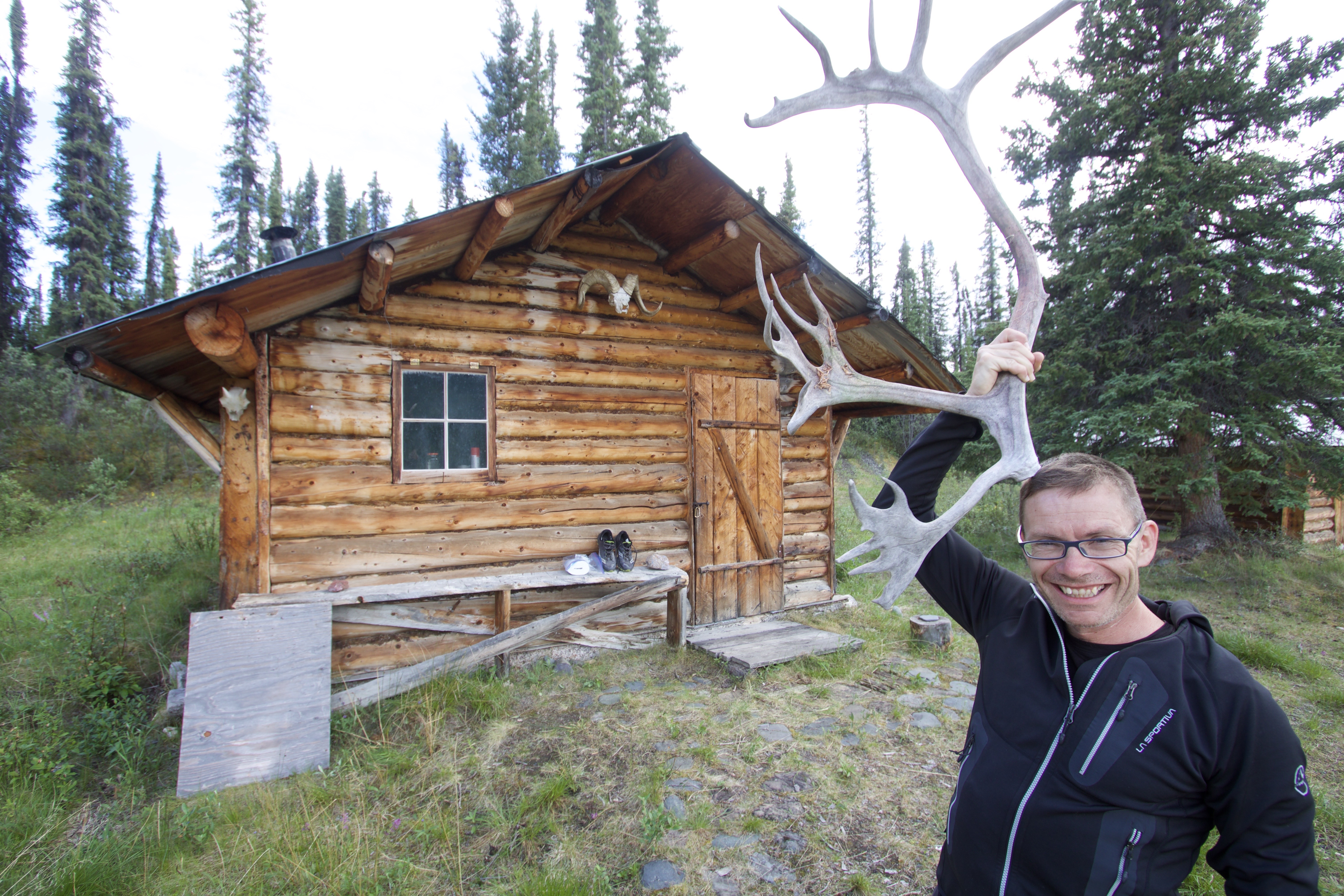
Oli with caribou antler
It was my third trip to Tatonduk. In 2015, while floating the Yukon River, I stopped at the confluence to get a glimpse of the surrounding area. In 2016, Mike Cragen and I embarked on an off-trail, 150-mile loop on the edge of east-central Alaska that toured the most remarkable, yet least visited areas bordering Yukon-Charley Rivers National Preserve. We named this ambitious circuit “The Borderpatrol” and it centered on exploring the Tatonduk. The route went across the Canadian border, down the Tatonduk River with packrafts (which, as far as I could tell, was the second descent of the South Fork) and back across the U.S. border. What we found did not disappoint. The geology in the valley was completely unusual to the subarctic. Hidden amongst the cliffs were several natural arches, slot canyons, caves, and even a miniature volcano which “erupted” in 2012.
Mini “volcano”. Standing here too long could melt the soles of your shows.
And to top it off––the Grand Canyon of the Tatonduk––which has vertical walls rising hundreds of feet to either side. It seemed unbelievable, but the gorge narrowed into a slot so tight––game animals could leap across it in one jump.
The valley was a geologist’s dream and a paddler’s nightmare. The area was so unique, I believed it could, and should be incorporated into some kind of natural preserve––just like Yukon-Charley Rivers National Preserve across the border. If it were, the two areas would be interconnected, protecting a huge swath of wilderness. So I brought my friends, my cameras, and my naiveté, and set out to document one of the most unusual and spectacular valleys in all of Yukon Territory.
* * *
The sun was beating down at 11pm––T-shirt weather in the land of the midnight sun. Dan had offered the use of his hunting cabin for the night. It was spacious, clean, but not exactly mosquito proof. We considered erecting our tents until we spied a guest book. The last two entries were dated a year ago.
Sept. 15- While scouting the west-ridge for moose,
we glass a huge, 10-foot grizzly on the tundra below…
Tom S.
Sept. 18- Griz dead and in camp. Measures just
7-foot 6-inch. Tom needs to see more bears.
Greg M.
We chose to sleep in the cabin. We weren’t ready to deal with the bears just yet. The comfy but primitive abode reminded me of legendary trapper Dick Cook, who homesteaded on the lower section of the Tatonduk. His exploits were documented in John McPhee’s classic book, Coming into the Country. Cook built his log-home by hand and lived there for nearly four decades. He had dealt with the threat of bears on a daily basis, it was all normal living for him. In 2001, Cook, who was then 70-years old, accidently swamped his canoe and subsequently drowned in the frigid waters. His body was found floating near the mouth of the river; proof that bad things can happen to even the most skilled, seasoned outdoorsmen. If it ain’t the bears that get you, I reasoned, it’s the river.
* * *
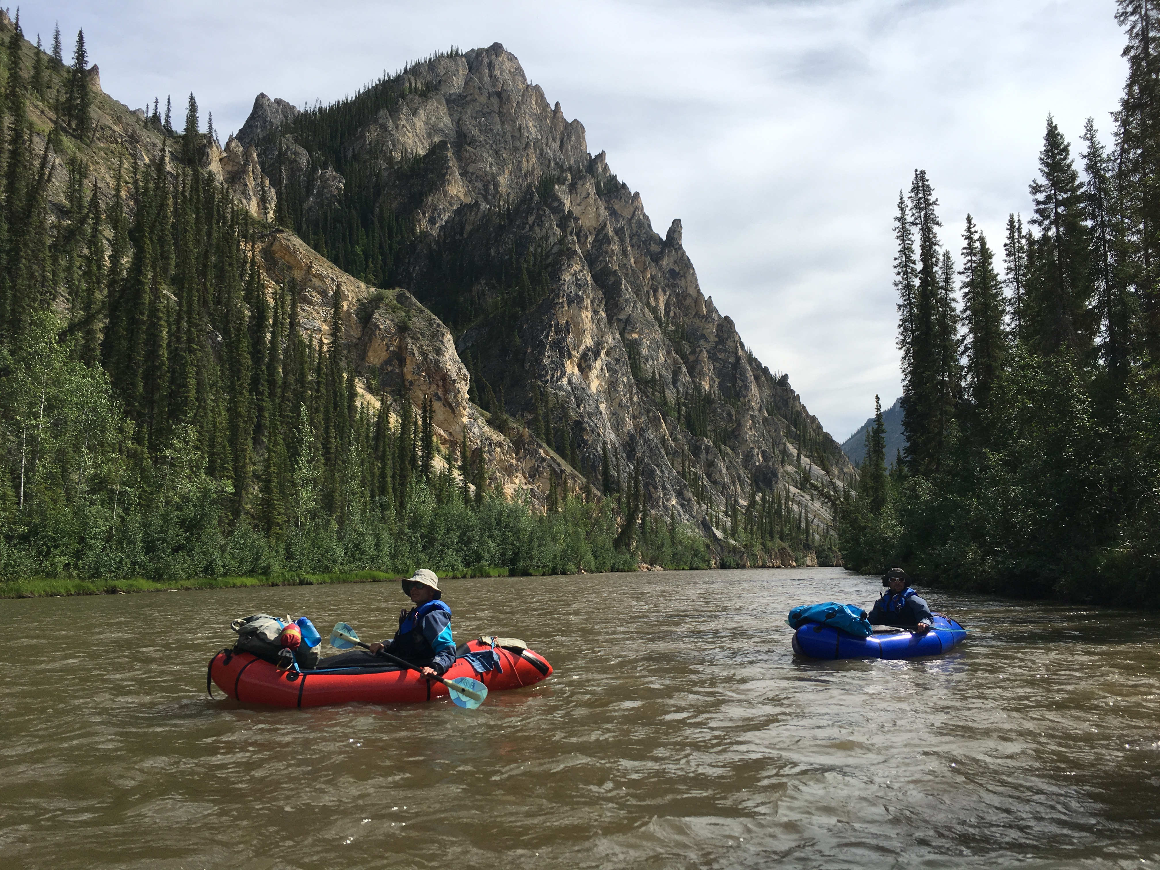
The next morning we inflated our packrafts and began the descent. The contour lines on our map pinched together, revealing the canyons ahead. But first we had to cruise past the meadow where the sheep were sleeping.
Dan never hunts this area and asks us not to disturb them. As quiet as we were, they smelled us. Thirty white sheep stampede for the river, splashing across in front of us, and quickly climbed the striated canyon wall until they were high above. Large rocks ricocheted down the cliff, cannonballing into the river around us. Was this an accident or were the sheep purposely trying to kill us? I also wondered––when was the last time these sheep had seen people?
* * *
In June of 1980, Jerry S. Dixon was working as a Fire Management Officer for the Bureau of Land Management (BLM) in Eagle, Alaska. He had been a smokejumper––a highly trained wildland firefighter who uses parachutes to access remote and rugged areas. But then he had an accident. Jerry is among the few smokejumpers in history to have survived a double parachute malfunction. Afterwards, unsurprisingly, he decided to stop jumping out of airplanes.
Jerry Dixon during 1980 first descent of South Fork Tatonduk River. Photo by Ron Watters
Jerry was the only BLM representative for an immense tract of public land around Eagle. The establishment of Yukon-Charley Rivers National Preserve had been proposed but not yet implemented, and in Eagle, there was almost unanimous opposition to the park. The idea that the government was now going to control the wilderness and demand permits for things like mining and hunting did not sit well with the residents. Store owners posted signs that read: PARK SERVICE NOT WELCOME HERE.
Although many of the townspeople thought of Jerry as ‘one of the bad guys’, he was outgoing, amicable, and he had something in common with most of the residents: he loved the Yukon wilderness.
Dixon was also a whitewater kayaker. During this time, he had accomplished a daring, solo first-descent of the North Fork of the Tatonduk River, was mesmerized by the area, and wanted a shot at the South Fork too. This time he implored his paddling friend from Idaho, Ron Watters, to join him in the adventure. Having flown over the South Fork and seen the canyons for himself, Jerry knew there would be some monstrous portages to contend with. The pair decided to use Spezi inflatable kayaks, which were heavy, but easier to portage than the typical 13-foot fiberglass hardshells of the day. The Spezi’s, however, couldn’t quite fit in a backpack. They also had a nasty reputation for wrapping around boulders, trapping their occupants. Packrafts would have been ideal, of course, but they had yet to be invented.
Jerry described the trip in his book Wild for Alaska. The duo named the many topographical features along the river which I have adopted for this article. Sadly, Jerry died of Lou Gehrig’s disease in 2010 and I was never able to speak with him about the accomplishment.
* * *
It was our second day on the river and we were having a blast. We felt like explorers discovering an untouched land for the first time. There was no trash, no footprints on the gravel bars, no evidence of logging, no incessant whine of airplanes flying overhead. The valley was ours and ours alone. This awareness was especially poignant for Oliver and Ueli who live in Switzerland. “In our country, every tree is accounted for,” said Oliver. “If you walk through a forest in the Alps, there are no fallen trees lying on the forest floor, they are harvested long before they ever touch the ground.”
“Camp fires are illegal too,” said Ueli. “You need a special permit, only certain people can get them, and it’s only allowed once a year.”
I looked at the healthy stands of black and white spruce and tried to imagine what it would be like to account for each and every tree. Oliver continued, “You can’t do a trip like this in Europe, every river is dammed. You can paddle short sections, portaging the dams, but camping is forbidden.”
We continued our paddle towards Mother Bear Canyon. I knew from Dixon’s book there was a hidden, river-wide, 25-foot waterfall somewhere along our path. Now, I like whitewater just as much as any river-runner who considers this type of hobby ‘fun’. But I am also conservative. Admittedly, some might say that I am annoyingly conservative. So yes, the idea of running an unknown canyon containing a hidden waterfall somewhere along its length––scares the hell out of me. However, the waterfall didn’t seem to bother Oliver or Ueli one bit. They were both keen to hit some real whitewater.
It should be noted that my friends’ first language is Swiss German. Their English is superb, however, some common phrases and idioms were simply lost in translation. So, I wasn’t sure if either of them had completely understood me. “Guys!” I said a little louder, “Do you know what I mean when I say waterfall? I don’t mean whitewater, I mean waterfall––the whole river going over a cliff.” I gestured with my hand to imitate a boat plummeting over a lip to certain death.
“Yes, yes, we understand.” They laughed, “We will scout from the river.” They jumped into their packrafts and sealed their skirts. Not wanting to be left behind, I nervously followed. We paddled out of the swirling eddy and dropped into a canyon with granite walls. It was tight and claustrophobic. I kept listening for the telltale roar of a waterfall. Would I hear it? The powerful current pushed us along through a series of wave-trains and splashy rapids, nothing difficult, but a flip could have proven serious.
Rounding a large bend, just 50-yards away, I saw the river disappear over the horizon. I yelled, “There it is!” We paddled quickly to a large eddy and exited the rafts. My mouth was dry. A great relief washed over me.
It was a hard portage with all our gear and boats to the base of Mother Bear Falls. The river cascaded 25-feet, ricocheting off polished conglomerate, and culminated in a cloud of mist and spray. It was a beautiful, tranquil spot––worthy of a roadside attraction in any National Park. But the hordes of tourists were thankfully missing, no network of roads or infrastructure there to support them, no array of port-o-potties leaking their stench into the landscape. The area was lonely in the best way possible; pure, unbridled wilderness.
The next two canyons, Thunder and Merganser, were more fun than frightening. The river felt small, splashy, like a flume ride at an amusement park. Scattered along the cliffs above, we spotted a series of natural bridges. Jerry and Ron named the most prominent which look like the gestures of a giant hand: OK Arch, Knuckle Arch, and Thumbs Up.
Eye of the Needle Arch
Arches rarely form in the Far North due to the slow dissolution of limestone during the long and cold subarctic winters. Even when these natural oddities have formed at high latitudes, they are usually destroyed by repeated glaciations. Just another example of how the Tatonduk Valley is a unique and special place. But it wasn’t the formations that had captured my imagination––it was the gorge ahead.
The word Tat-on-duk comes from the Hän Athabaskan word which roughly translates to Broken Rock. That might be the best description of the gorge we were about to encounter. Imagine a mountain that has split in half, the entire river forced through the crack. Ron Watters sent me this vivid description of the canyon as he remembered it.
Beginning of South Fork Tatonduk ‘Grand Canyon’
“The walls are smooth and vertical, sometimes overhanging. The water is slow at the beginning and it’s strangely inviting. You can almost hear the Sirens inviting you in. It might be tempting to paddle a short distance––just a short distance––to see what it’s like. But if you did, it would be a black widow’s embrace. You would be there for the duration––however short or long that might be. Once in the gorge there would be no way to climb out from river level. And what might you encounter? Walls closing in. The river beginning to hurtle downward. Then the black widow herself: a mass of logs forming a narrow spiny plug extending 30 feet or more above the surface of the river.”
The ‘spiny plug’ Watters is referring to is every river-runners worst nightmare: a strainer of monolithic proportions. Years of debris piled together to create a natural dam capable of purifying the river of any unfortunate soul brave enough, or dumb enough to get near it. I have paddled a fair share of rivers and have never seen a strainer able to form in a river with such high volume. It was impressive and terrifying at the same time.
Jerry Dixon straddling the ‘Black Widow’. Photo by Ron Watters.
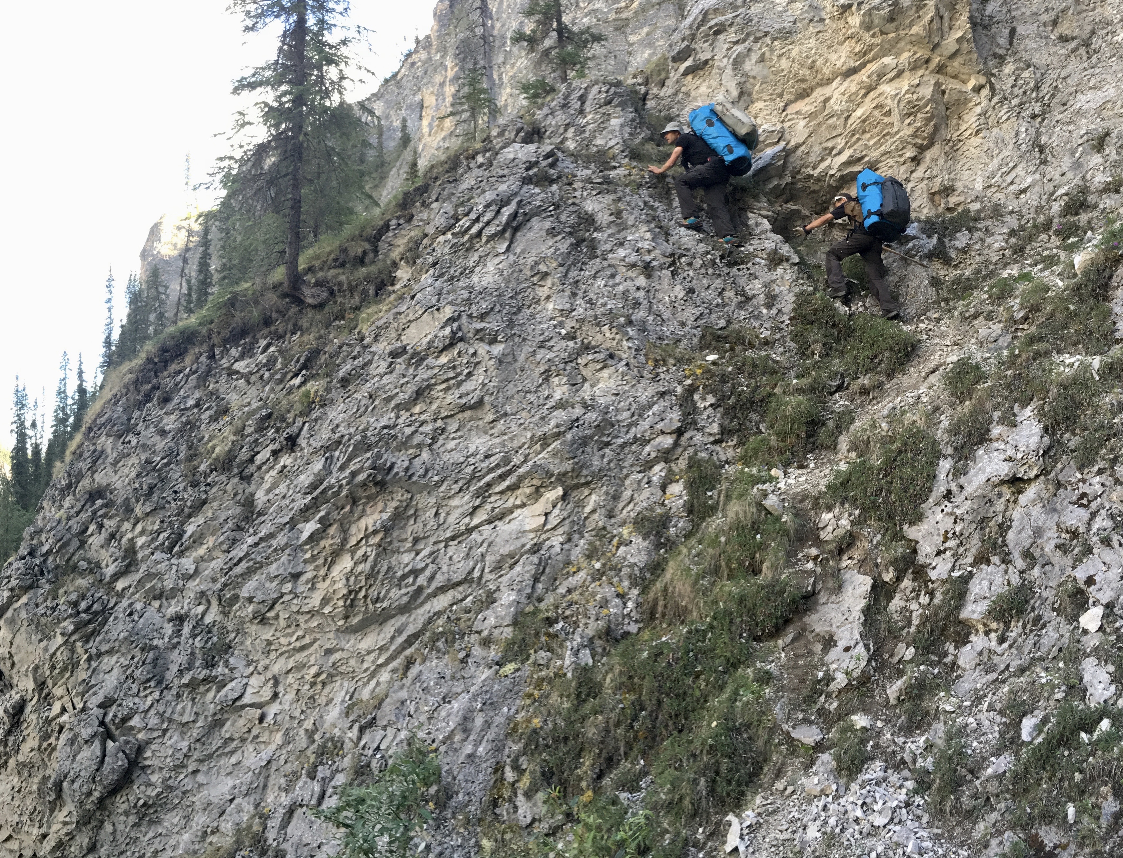
I had tried to circumvent this obstacle by portaging down the left side of the canyon with Mike Cragen in 2016. This was a mistake. After an hour of hiking with heavy packs, on scary precipitous ledges, we were cliffed-out and forced to retreat. This was the same cliff that Oliver, Ueli and I had brought climbing gear for. Our objective was to reach the Eye of the Needle––the largest arch in the valley––it stood like a sentinel on the canyon rim overlooking the gorge. There was a distinct possibility that no one had ever been there before.
Oliver and Ueli are expert mountaineers and have climbed all over the Alps together, so I was more than happy to relinquish the rope to them. At the base of the 40-foot cliff, Ueli took the lead. The rock was flaky, unprotected, and looked more difficult than I had remembered. At the start of the climb, there was a small tree which had grown out of a crack in the rock face. If Ueli had fallen just above this, the rope might have caught the tree and arrested his fall. But he had climbed above this point-of-safety and was traversing far out over the void to find better holds. If he slipped, he would have fallen past us and hit the boulders some 70-feet below. No one spoke. Oliver grew silent as we watched his brother-in-law make the final, delicate moves to the top. Soon, Ueli had an anchor built and was belaying us up.
Ueli on lead
At the Eye of the Needle, we took photos and ate sardines. There was no evidence that anyone had been there before us, and we made sure to erase any evidence of our own passing. The following day, we would see a Dall sheep standing on top of the arch; seemingly to mock our efforts. In the distance we spotted another natural bridge, this one undocumented. You would only be able to see the hole in the rock from our vantage point. I decided to name it Swiss Arch, in honor of my two friends, who had travelled halfway around the world to share this adventure. I might have come here without them, but I was glad I didn’t have to.
Eye of the Needle
Inside the gorge, the river hurtled down into a fissure and disappeared. We couldn’t see the black widow herself but we knew she was there––right where the canyon was at it narrowest. A faint game-trail led towards this spot and then continued on the opposite side. It was true, game animals could leap across the gorge in one jump. Downriver, there was an adjoining valley with sheer walls rising to either side. It would take ropes to access. Had anyone ever been there? I believed, with good reason, the valley would remain unexplored until our return.
The Tatonduk Valley has remained pristine because very few people know of its existence. For a long time, I debated writing this article for that very reason. Simply publishing these words could reveal it to the wrong people, perhaps those who would rather profit than protect. However, if no one knows of its existence––no one is likely to care about its defilement either. Luckily, the remote location and subarctic winters will keep most people at bay. Most.
Author and naturalist Henry David Thoreau once wrote, “In wildness is the preservation of the world.” It is a lovely but often misrepresented statement. Thoreau wasn’t writing about the wilderness; he was talking about the wild spirit within people. When visiting Tatonduk, I felt that wildness. How could I not? It inspired me to do what I could, however little, to protect this savage paradise. For now, I rest assured that as long as Dan Reynolds is managing his hunting concession, the area will remain protected and wild indeed. The only question remains: For how long?
*Authors note: Landowners approval was always granted prior to the entry of described caves. Furthermore, Camuy Caverns Park was never entered without permission, even underground, and all laws were obeyed.*
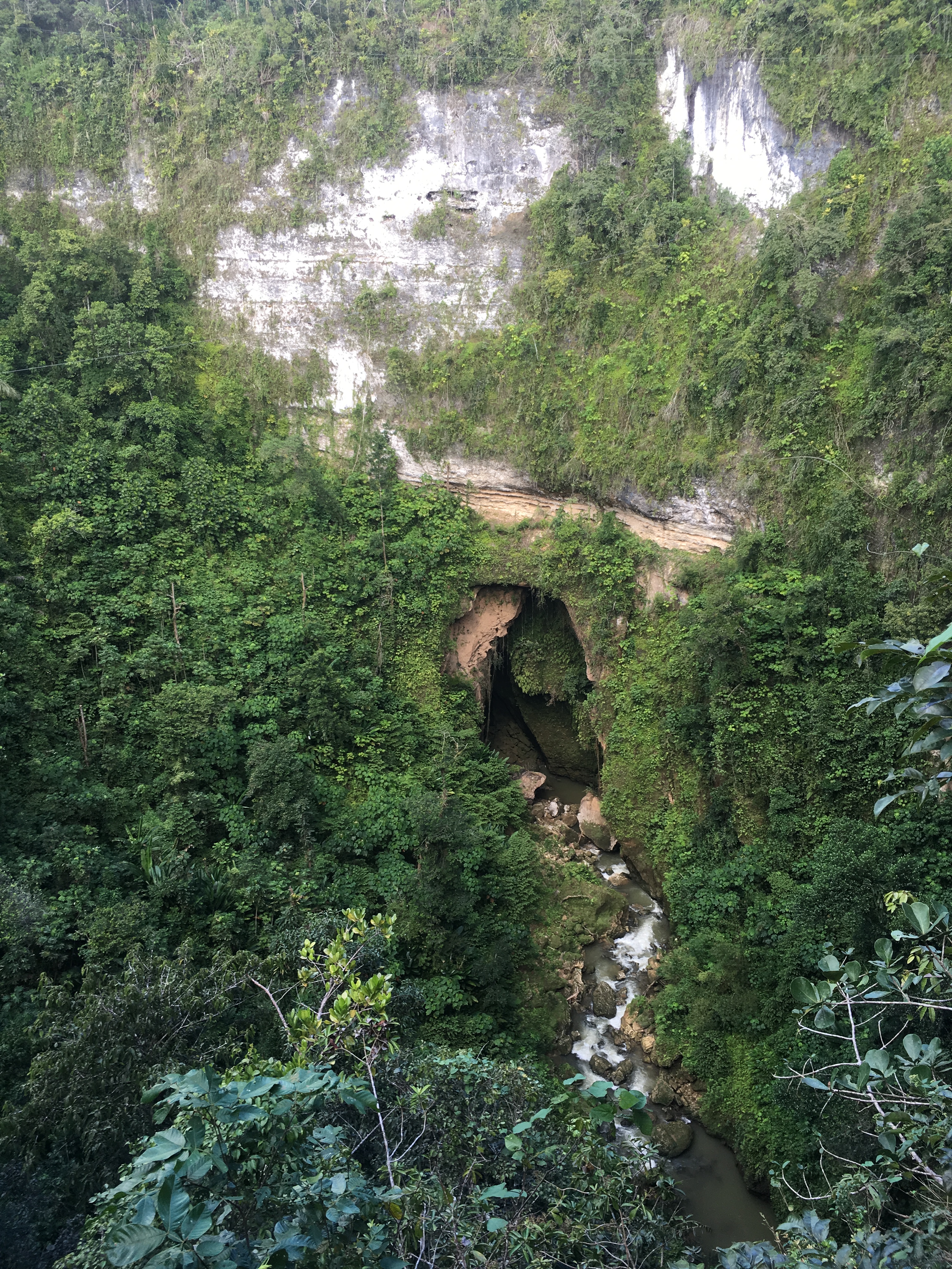
“Tenga cuidado,” he warned. The store-keeper guided Russell and Jeanne Gurnee a short distance, just across the road from the parking lot. Sí, there were caves in the area, and sí, he could show them one. The man pulled back a curtain of vines and to their complete surprise, an enormous pit was revealed––it was at least 100-feet in diameter. The cavers from New Jersey gasped as they took in the immensity of what they were seeing. The edge of the mighty sinkhole was overhanging, and the jungle–– which was perched precariously at its lip––leaned inward as if trying to get a better look. The couple crawled on their stomachs, getting as close to the edge as they dared. The pit appeared bottomless, but the telltale roar of rapids—El Rio Camuy—could be heard echoing, hundreds of feet below.
The year was 1958. The sight of Empalme Pit would mark the beginning of the Gurnee’s obsession with the Rio Camuy’s underground labyrinth. In time, they would organize and lead four major expeditions to the island, which would reveal the Camuy as being the third-largest underground river in the Western Hemisphere. Some of the caverns they discovered were so huge, their meager lights could not sufficiently illuminate them; only bursts of flash-powder could produce enough lumens to momentarily reveal their scale.
Cueva Agua Evaporada–Sistema Camuy
Thanks to the Gurnees, the land above the caves was eventually purchased and the Parque Nacional de las Cavernas del Río Camuy was created. Lights were wired, boardwalks and stairs erected, even a trolley was installed. The park could support 1,500 tourists a day and was readily sold out. Prior to 2008, it was the most popular natural attraction on the island.
But over the years the park had seen some tragedies. In 1968, Hector Bueso, aged 30, was on a guided tour of Tres Pueblos Sinkhole, when the river suddenly flooded and swept him into the downstream cave entrance; his body was never recovered. In 1975, Francis McKinney––an experienced caver who had been awarded the prestigious National Speleological Society’s Fellowship Award––fell 75-feet to his death while climbing out of the Ventosa entrance. In 1999, Francis Reyes, a caving instructor and guide, drowned during a flood pulse in Cueva Angeles (although technically not inside the park, Cueva Angeles is part of the larger Camuy cave system). In 2008, Socorro Elain Smith, a tourist from California, was killed by a falling rock while waiting with her husband to board the trolley out of Tres Pueblos Sinkhole. In 2011, an employee of a zipline operator, Jorge Len Rivera, aged 34, drowned while installing a cable across Tres Pueblos Sinkhole when a flood pulse swept him into the downstream cave entrance. In 2016, María Lisardi Vázquez, a 32-year-old zipline operator, lost her footing and fell over 400-feet into Tres Pueblos Sinkhole. The Sistema Camuy has claimed more lives than any other cave or cave system in Puerto Rico; most of them technical experts.
Looking into the downstream cave entrance of Tres Pueblos Sinkhole
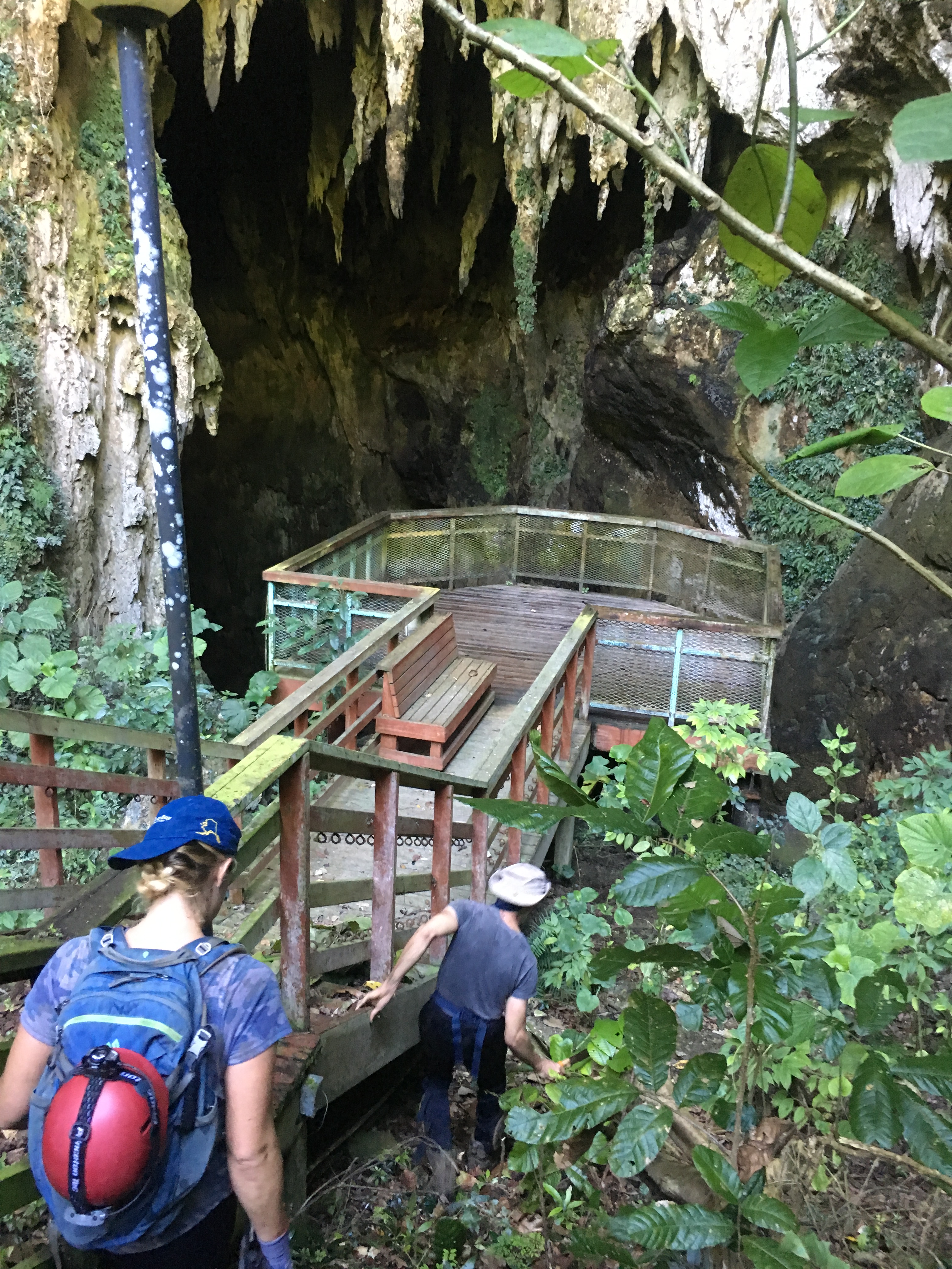
By 2009 the park was falling into disrepair. The long boardwalks which provided tourists access to cave entrances and observation decks were beginning to rot. Fallen trees and landslides blocked the roads. With astonishing speed, the jungle was reclaiming the land.
Rotten boardwalk above Cueva EspiralCueva Espiral. It’s safer to stand on rock than to trust the rotten observation deck.
Then came the final blow. Maria––the category-5 hurricane which devastated the island in September of 2017. The amount of water which flooded the caverns was biblical. Tres Pueblos Sinkhole flooded to an instant lake with an estimated depth of over 200-feet. Many of the tourist facilities were destroyed or washed away. It appeared the cave’s large bat populations had either been wiped out or evacuated. The park was unceremoniously closed, and has been ever since.
The closure of one of Puertos Rico’s most popular natural attractions has been detrimental to the local community and the loss of state revenue for an already struggling economy has done little to help its future prospects. However, the Federal Emergency Management Agency (FEMA) has allocated 14-billion in disaster relief since 2017. In August of 2020, an additional 84-million was allocated for recovery projects, and of that, 12-million was designated for repairs to parks and recreational facilities. Whether Camuy Park will receive any of that money is still being decided.
Like Jeanne and Russell before us, Ashlee and I had become obsessed with the Camuy Caverns. We were residents of Puerto Rico, cavers too, and had spent many long weekends exploring the island’s karst. We had seen old, pixelated photographs of the park, and since our equipment was modern, we knew we could do better. We sensed an opportunity to photograph these magnificent caves the way the Gurnee’s saw them in 1958––in their original state, before the guardrails. Perhaps our pictures could be used to garner attention and aid in the restoration of the park? It was a wonderful thought.
We tried a dozen times to request a permit from three different authorities but never received a response. The park entrance was guarded 24/7 and our Spanish wasn’t good enough for schmoozing. However, our research had shown there were other ways to legally access the caverns: areas outside of the park.
Blue Hole would be our first try at a backdoor. The Camuy begins as any other river which flows lazily across the surface of the land. Blue Hole is the point where the river burrows underground. We knew from the book Discovery at the Rio Camuy that the Gurnee’s had also employed this tactic. However, we wondered if anything had changed during their 60-year absence. Ashlee and I hiked to the river and walked downstream. We arrived at the base of a cliff and found a massive choke of logs, bamboo, and debris. Over a thousand years, every branch, twig, and leaf that had fallen into the river was piled here. It was the mother of all strainers.
Blue Hole
There were large driftwood logs 30-feet up into the trees, evidence that the area becomes a lake when flooded. To access the caves this way would require a great deal of explosives to remove the plug. How this curious spot ever got the name Blue Hole was a complete mystery to us.
Our next attempt would be through Cueva Humo––or Smoke Cave––so named for the great number of bats which can resemble smoke as they depart on their evening forays. I had a general idea where Humo was located but the information proved insufficient to say the least. The jungle was thick, nearly impenetrable.
Cueva Humo
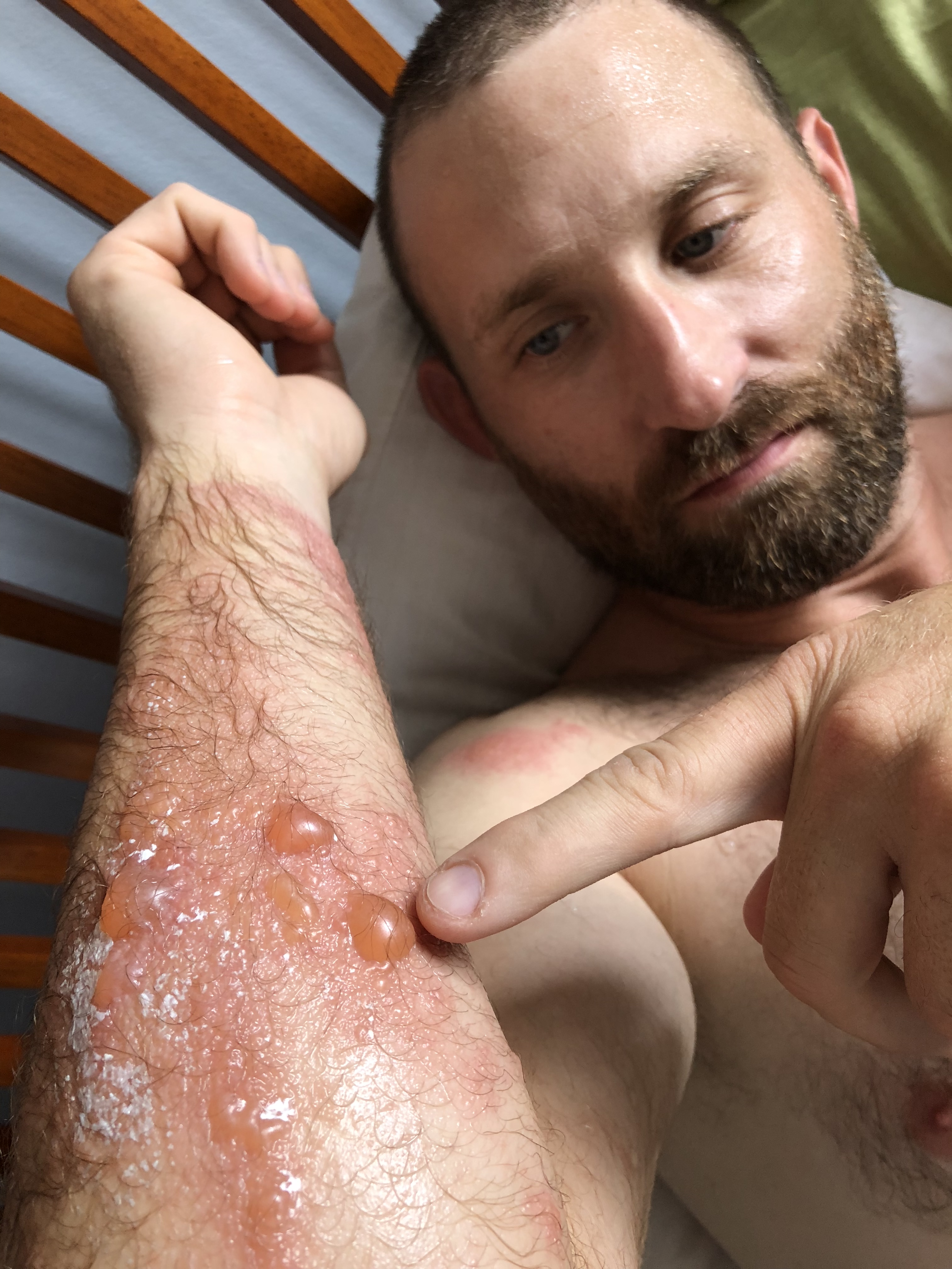
You could not go a step forward without first chopping a hole through the vegetation. There were ants everywhere, falling off the trees and down our collars. I would soon become familiar with a little plant called Carrasco. Carrasco is related to poison sumac but its effects are much, much worse. Three days later I was in the hospital getting steroid injections. The skin on my arms bubbled up and became infected. It looked like blisters from a third-degree burn and itched like nothing I’ve experienced. Luckily for Ashlee, she did not have as severe a reaction as I did.
My carrasco blisters
Our third try was the Camuy Resurgence––where the river reappears after traveling underground for several miles. We entered the cave with headlamps on and followed the river up-stream. The river was swift and in certain sections we’d swim against the current as fast as we could, momentarily clawing the wall to catch our breaths. In this fashion we pushed through several small chambers until our path was blocked, once again, this time by a large breakdown pile where the ceiling had collapsed. The water could squeeze through the cracks but we could not. We had failed… once again.
Rio Camuy Resurgence
In our desperation we decided to join a caving club. It should be noted that I’m not a fan of clubs. Maybe because I’m an introvert. Or maybe it’s the associated fees I don’t like. Or maybe it’s because I’m wary of cults, and clubs seem to have a lot of similarities. Whatever the case, it had gotten to a point where we were spending too much time looking for caves and not enough time actually inside of caves. In fact, two weeks prior, we had spent an entire day looking for Cueva Perdida. The name translated is Lost Cave. After several hours of hacking at the jungle, promising my friends their efforts were worth the search, it slowly started to dawn on me how the cave got its name.
In desperation I contacted Sociedad Espeleológica de Puerto Rico (SEPRI) hoping someone there spoke English. We met some very nice, interesting people and in time, made some very good friends. But that didn’t necessarily mean they were going to divulge the location of certain caves. Those, apparently, would need to be earned.
Tom Miller, Carlos Artiguez, Me
Our determination had been paying off elsewhere. We found the long lost Cueva Perdida after three tries and Cueva Humo after two. Neither had been visited since Hurricane Maria some three years earlier. We thoroughly explored 23 other cave systems on the island (often with friends from SEPRI) reopening the trails to each of them and gaining valuable experience along the way.
We had been dreaming of the Camuy Caverns for nearly two-years and it looked as though our employment on the island was coming to an end. We decided to refocus our attention entirely on Camuy. We had become cavers, afterall, and we were not about to leave Puerto Rico without seeing the most spectacular caves on the island.
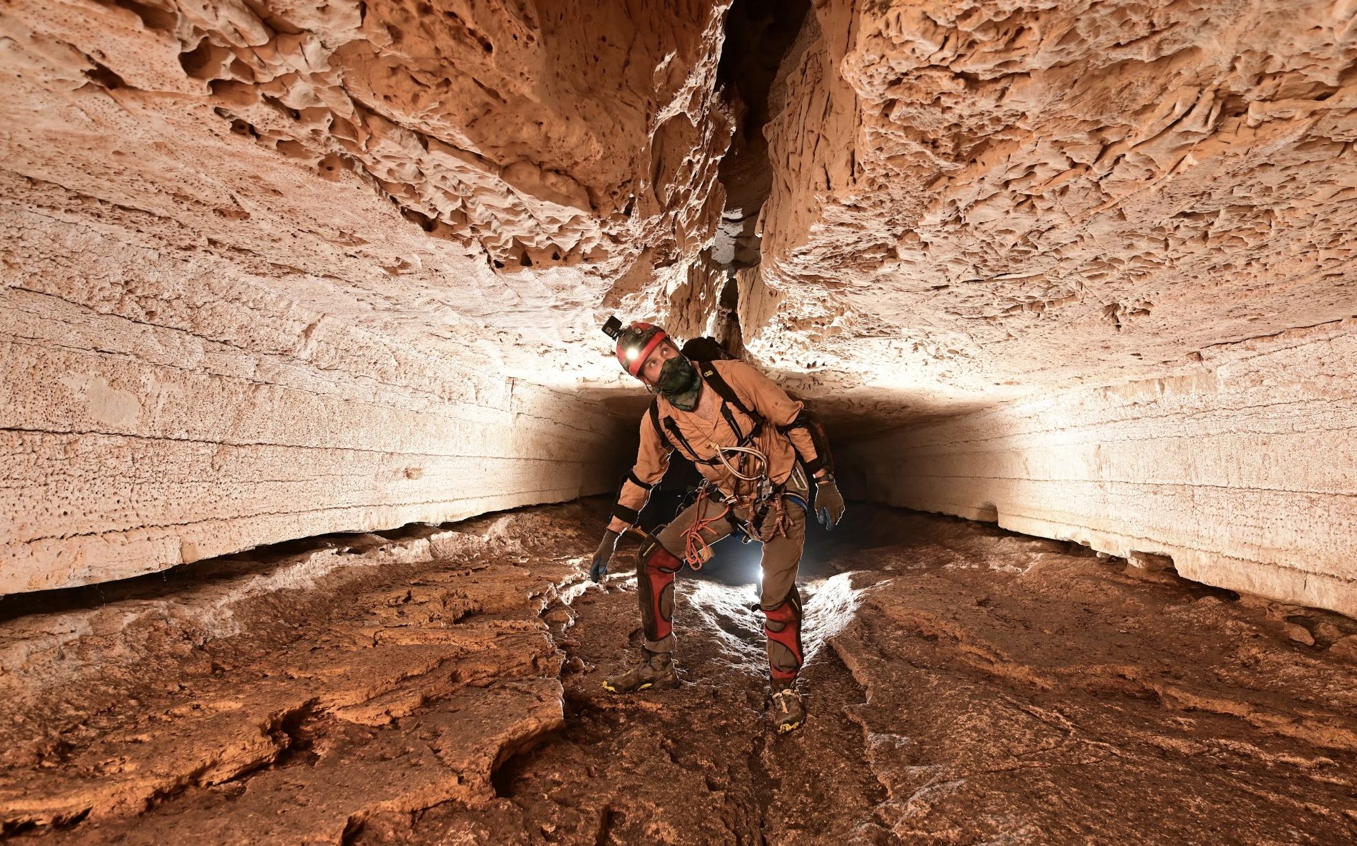
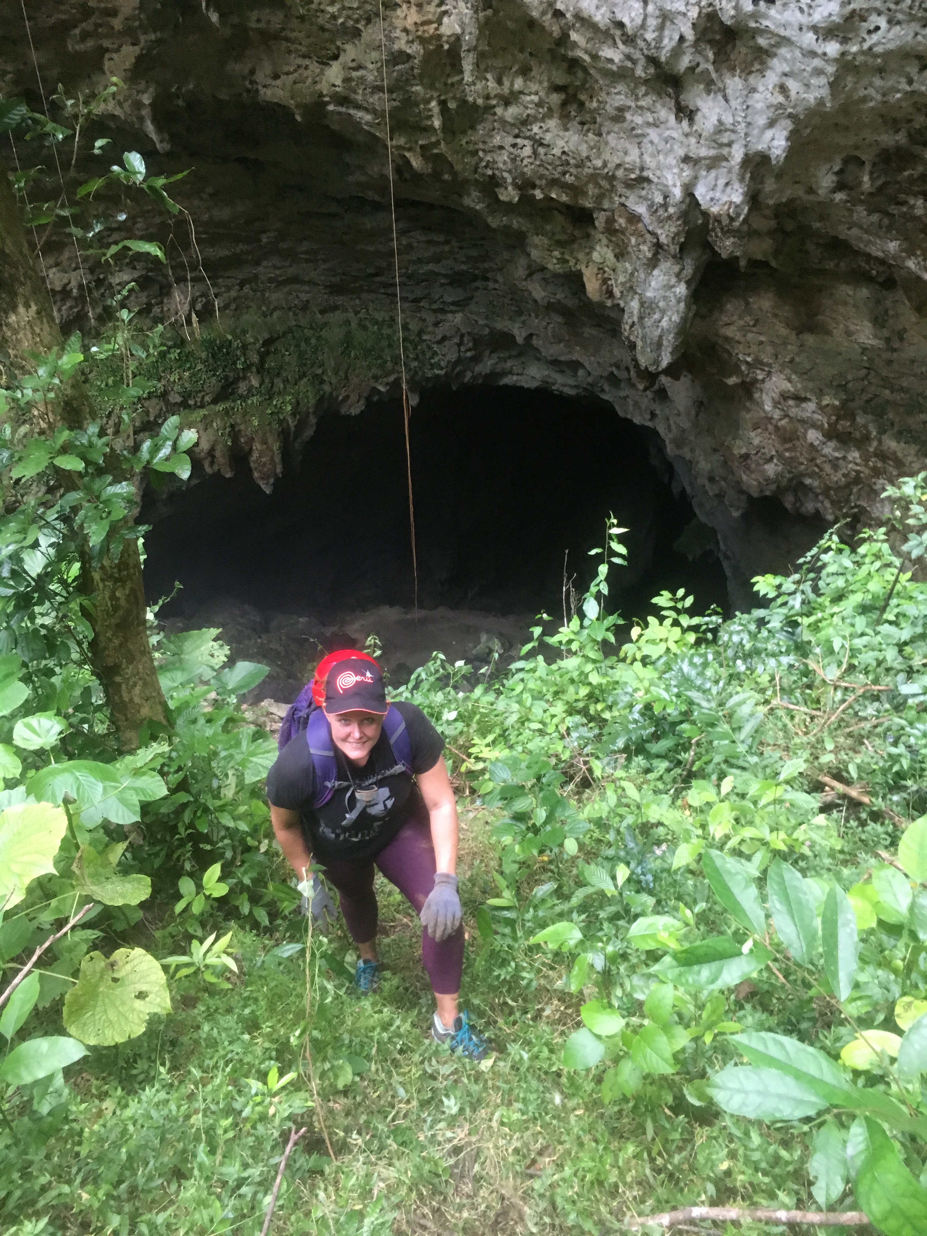
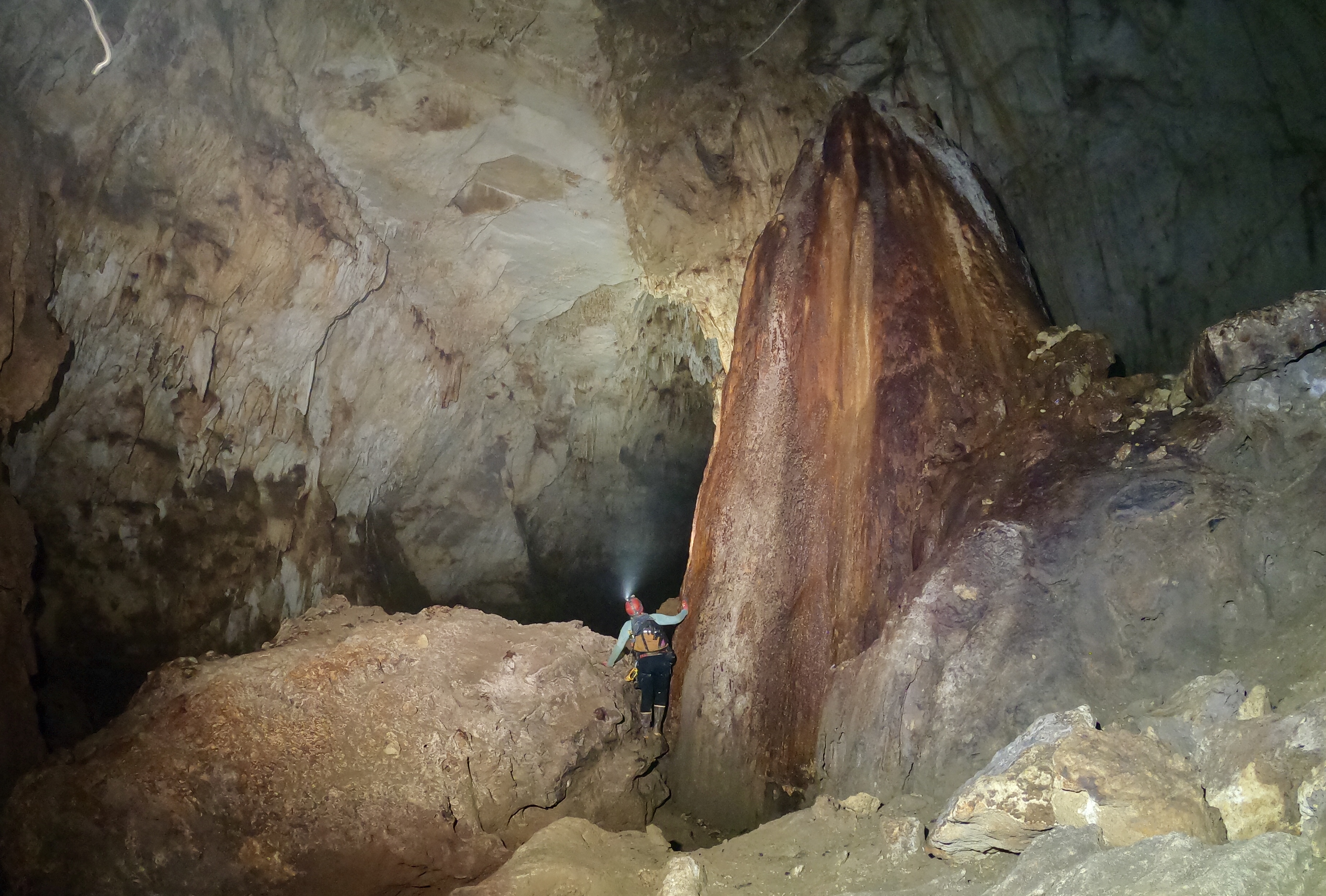
In trying to find our way into the Camuy Caverns, Ashlee and I tried going through the front door at Blue Hole, we tried the side door at Cueva Humo, and we tried the backdoor at the Camuy Resurgence. The only entrance left seemed to be the chimney. La Ventosa––Spanish for ‘The Sucker’––is an unassuming man-sized hole on the side of a hill. This small entrance leads to a balcony which overlooks a dizzying, 300-foot vertical drop to the Rio Camuy far below.
We hiked up the hill with our ropes and climbed over the barbed-wire fence which prevents cows and stray dogs from falling in the hole. There was a noticeable breeze as the vacuum of La Ventosa lived up to its name and lured us into the darkness.
With headlamps on we quickly negotiated a short 15-foot rappel and left the rope for our climb back out. Down at knee level was a descending crawlway. We squeezed down this chute and entered a large domed room which gave the impression the entire hill we had just been walking on was completely hollow. Carefully, we made our way to a balcony which overlooked a mighty abyss. The echoing rush of the river could be heard far below. We switched our headlamps to spot-mode but the combination of our focused beams was still unable to reach bottom. The total distance of both rappels would equal the height of the Statue of Liberty from torch to foundation.
There was an old but sturdy looking anchor. We added some webbing for insurance and threw the rope. For three and a half seconds it whipped through the air, finally hitting bottom with a muffled slap.
“Holy crap.” I said, “That was some serious airtime.”
Ashlee nodded, “This is going to be epic.”
Clipping my micro-rack into the rope, I tentatively walked backwards over the edge. I slowly descended off the balcony and away from the warm glow of Ashlee’s headlamp. I was soon bouncing off the cave wall like a moonwalker. It was unnerving not to be able to see the bottom of the pit, the white rope disappearing into the darkness below. Then the walls of the cave belled out and I was suddenly hanging free, slowly spinning down like a spider from its web. It began to dawn on me that the climb out would be much more difficult than I expected.
A boulder-strewn ground materialized below. The nylon rope began to smell of burnt rubber as I slowed my descent. Once my feet touched ground, I unclipped the rack and took a good look at my surroundings. I was in the middle of a cathedral-like room, the cave continuing in both directions. It was as if I was standing in the middle of a huge canyon at night. It was by far the largest cave I had ever seen. I switched on the walkie-talkie.
“Okay Ashlee, I’m off-rappel. Please be careful.”
“Coming down.” She said cheerfully.
Looking down Ventosa
Far above, Ashlee’s headlamp resembled a solitary star in the night sky. I watched her begin the rappel, slowly bouncing down until the cave belled out and like me, she also began slowly spinning; this time her light resembling a lone firefly buzzing around in circles.
Ashlee near bottom of first rappel
She touched down with a huge smile on her face. “Wow, that was incredible!”
“Not over yet,” I replied. “We’ve got another rappel.”
We gathered our bags and then flagged the rope with reflective tape which would make it easier to find in the large room. It was literally our lifeline. We had no communication with the outside world and needed to take every precaution available.
Just downhill was a house-sized stalagmite which thrust upwards like a mighty tusk. Stalagmites typically have a corresponding stalactite of equal or larger size hanging from the ceiling but it was too high and our lights too weak to see it.
The Tusk
We continued down the muddy slope, we knew there was another big drop but didn’t know exactly where. We thankfully found an old rope running horizontally along the wall. We attached ourselves with a carabiner and continued to the edge of the drop.
The edge was on an overhanging pedestal of limestone which looks like a candle that has melted to the hilt. We tentatively peered over. A fine mist reflected our lights and prevented us from seeing bottom. The cacophonous rumble of rushing water was much closer now. I imagined rapids.
I thought aloud, “I don’t know if we should do this.”
Ashlee turned, temporarily blinding me with her headlamp. “What do you mean? Why not?”
“We can’t see the bottom.” I said, shaking my head. “It sounds like we’re going to rappel straight into the river and we don’t know how deep or fast it is. Sounds like it’s really churning down there. Besides, we already have a hell of a climb out. Maybe we should come back another time.”
“Another time?” Ashlee asked, confounded. “We did it, we’re here, and it’s so close.”
Her reaction made me smile. Typically these caving trips had been my harebrained ideas. On more than one occasion I led us on some wild-goose chase to some obscure hole in the ground where we’d find nothing more than filth and exhaustion; adventures that would test the resolve of even the most hardened relationship. But over time she had caught the caving bug too and now it seemed her determination to see the Rio Camuy was even stronger than mine.
“Okay.” I said with a weary smile. “Let’s do it.”
“When you get down to the river,” she said, “If it looks too deep, just do a change-over and climb back up.”
I nodded, feigning confidence. Although we’d practiced change-overs (the ability to switch from descent to ascent with the aid of rope-grabbing cam devices) many times at a local crag, doing one on a hanging rappel, 300-feet underground, above a frothing river––was a nausea-inducing proposition.
Swallowing my hesitation, I threw the rope and began the descent. Even halfway down, the mist swirling around my feet prevented me from seeing bottom. The nearest wall began to look wet and polished, the roar of rapids getting ever louder. Finally, the mist parted and I did not like what I saw. The cave appeared to be bottomless, the void continuing to infinity. I looked to see how much rope I had left. It looked as if a great wind was blowing the rope back up towards me! I suddenly realized it was an optical illusion. The river below was calm and clear making it look black in the reflection of my headlamp. The end of the rope was floating in the water. Down-canyon the river cascaded through a sieve of large boulders. It was hard to determine how deep the river was, so I slowly lowered myself into the water. I thankfully touched ground at thigh level.
I waded to a nearby gravel bar and radioed Ashlee who was down to the river in a matter of minutes. I took a video as she rappelled into the Rio Camuy––a moment we had been dreaming about since we started caving on the island some two years before. I waded back into the water and we hugged. It was a short celebration, however. We were in the belly of the beast now; congratulatory speeches could come later.
Upstream, the Camuy River flowed placidly through a slot canyon with high vertical walls. It reminded me of The Narrows–– a popular destination in Zion N. Park, Utah which frequently sees hundreds of visitors a day.
Rio Camuy
If we continued in that direction, we’d eventually make it to the Hall of the White Maidens: so named for the gallery of statue-like formations that resides there. However, we were more interested in seeing the enormous dimensions of the Big Room and the twisting skylight of Cueva Espiral which opens up 300 vertical-feet above the surface of the river.
We hiked downstream until our path was blocked by a pile-up of large boulders and the thrashing rapids we had heard from above. We attempted to circumvent the obstacle by scrambling up and over the boulders. There had been an accident in this area during the 1962 Gurnee Expedition when a member of the party, Joe Lawrence, had trusted his weight to a boulder the size of a refrigerator when it unexpectedly rolled, throwing him from the rock and then trapping his arm beneath it. The team rushed to his aid, frantically scratching at the dirt and rock around his arm until they freed him. Unlike Joe, we did not have a team of rescuers at our side if such an event were to happen to us. We agreed that we had pushed our luck enough for that day. Also, the sure-to-be-exhausting rope ascent lingered.
Sistema Camuy
Ashlee and I took one last look around, the beam of our lights crisscrossing through the blackness. Our eyes strained to see the wonders surrounding us. We were filthy, hungry, and soaking wet. But at that moment, we had an entire national park to ourselves. In our minds, it was as close to buried treasure as we were ever going to get.
The ascent up the ropes was long but uneventful. Outside the cave entrance, night had fallen and the jungle had come alive with a symphony orchestrated by frogs and insects. As we hiked to the car, I couldn’t help but think of the natural wonders in the ground below our feet. All that beauty and grandeur hidden in the darkness for no one to see.
Camuy Upper Dry Passage. We called this the Death Star Formation (above).
But then it happened: On March 24th, the Parque Nacional de las Cavernas del Río Camuy reopened and was allowing visitors for the first time in nearly four years. Only one cave was accessible, Cueva Clara, and only 20 visitors a day could see it. But hell, it was better than nothing. Ashlee and I got in the car and rushed to the park entrance. There wasn’t a line or any cars in the parking lot, but when we pulled up to the entrance with smiles on our faces, the guard informed us that all the tickets were sold out. I couldn’t help rolling my eyes.
For now, most of the spectacular formations of the Camuy will remain in the dark, waiting for some brave and determined individuals to open the doors wide and share them with the world.