2013-2014 South Pole Traverse – Day 13

Day 13
Miles Advanced: 64.6
Miles Total: 708.8
Location: Leverette Glacier
Weather: Sunny, 11F


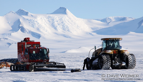
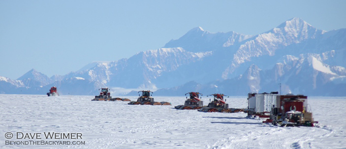
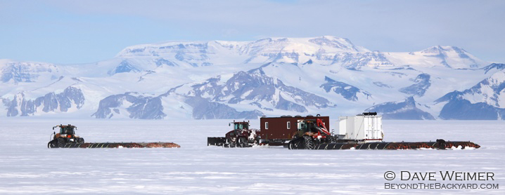
We started the ascent of the Leverette Glacier. It’s every ones favorite part of the trip because the views of the surrounding mountains are fantastic. Especially up the Scott Glacier. Bald, pyramid shaped peaks jut straight out of blue ice and tower above like sentinels guarding the valley. Those peaks are a rock climbers dream, I wonder if they’ve ever been climbed.


At the base of the Leverette we built a large snow berm to cache our fuel on. We place our bladders on top of the hill so our fuel isn’t completely buried by snow when we return.


We were told that SPoT2 will be leaving McMurdo shortly and for some reason they can’t find any shovels. They claim we “accidentally” took them all. Personally, I require TWO shovels on my tractor at all times. Additionally, I keep one shovel under my bed in case my roommate tries anything. I also require three spare shovels just in case I break the three I previously mentioned. Anyway, if SPoT2 gets stuck in a snowbank somewhere (which I’m sure they will) we will be more than happy to come save the crybabies.


Leverette Glacier
Leverette Glacier


Leverette Glacier
Leverette Glacier


Scott Mountains
Scott Mountains

2013-2014 South Pole Traverse – Day 12

Day 12
Miles Advanced: 76.3
Weather: Overcast, 13F


Today we crossed the Shoals- an area known for crevasses. During our scan we found them to be deep and narrow and would not pose a threat. We carried on without incident.


We are within 35 miles of the mountains now and they loom above. Today I watched my map closely because I wanted to see the Axel Heiberg Glacier. The Axel is the river of ice Amundsen used as his ascent route to the polar plateau and eventually the South Pole where he would become the first person to ever set foot there. Even with a map and GPS I had trouble identifying the Axel Heiberg. You can see the base of the mighty glaciers but where they derive is questionable. Amundsen was an amazing navigator, that’s for certain, but he must have also had great intuition. I can see the glacier just as Amundsen and his men would have seen it a hundred years before and I doubt it’s changed much in that course of time. Without a map, I personally would not have chosen the Axel as a possible means to attain the plateau as it makes a severe turn to the west and appears to dead end at the base of the mountains. Obviously, I’m no explorer. Anyway, I don’t think anyone has ever repeated the ascent of the Axel Heiberg. A decade ago some Norwegians on snowmobiles tried but two of them fell in crevasses and one of them died. The Norwegians were rescued but the dead man’s body was never recovered.


Queen Maud Mountains


Fortner
Fortner


Room
Room

2013-2014 South Pole Traverse – Day 10

Day: 10
Miles Advanced: 75.7
Miles From McMurdo: 488.1
Weather: Ground Storm, wind at 35 knots, 11F
Blue sky above but ground storm persisting. We made good time with no mechanical difficulties save the snow clogged air-filters on the Rinoth. We changed them out and are thawing the frozen ones on the generator. They should be good to go tomorrow.
Crossing the Ross Ice Shelf is a lot like crossing an ocean, except we drive instead of sail. “Water water everywhere but not a drop to drink.” In all directions a white loneliness stretches to the horizon. It’s a humbling sight because it makes you feel small and insignificant.
In the pictures you will see our Incinolet- which burns our crap AND our asses. You will also see Fortner and Jeff doing what they do in the Living Module. And there too is the Kitchen Module. All water comes from the snowmelter, which we fill about two or three times a day.

incinolet
Incinolet


Living Module
Living Module